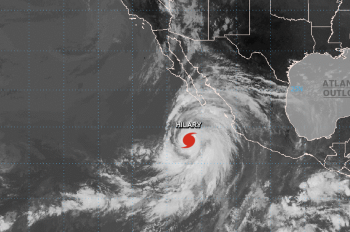
Southern California is bracing for a significant weather event as a powerful storm system makes its way toward the region. Residents of South Pasadena, San Marino, and Pasadena, & Highland Park are advised to be prepared for severe weather conditions.
The National Weather Service has issued storm warnings for the affected areas, predicting heavy rainfall, strong winds, and potential flash floods. The storm is expected to make landfall within the next 24 hours, and its effects could last several days.
Officials are urging residents to take necessary precautions to protect their homes and property. Local authorities recommend securing loose outdoor items, clearing storm drains, and checking on vulnerable neighbors and family members. It is also a good idea to stock up on essentials like water, food, batteries, and medicines in case of power outages or other emergencies.
Travel is likely to be affected, with roads prone to flooding and debris, as well as the possibility of flight delays or cancellations at nearby airports. Residents are encouraged to stay indoors and avoid travel unless absolutely necessary.
Tropical Storm Watch Issued as Hurricane Hilary Approaches Southern California
Current Watches and Warnings:
A Tropical Storm Watch has been issued for:
– Catalina and Santa Barbara Islands
– Antelope Valley Foothills
– San Gabriel Mountains
– Interstate 5 Corridor
– Santa Clarita Valley
– Highway 14 Corridor
Storm Information:
As of now, Hurricane Hilary is located approximately 1150 miles south-southeast of Avalon, CA, and about 1190 miles south-southeast of Los Angeles Airport, CA. The storm is moving northwest at 10 mph and currently has an intensity of 145 mph.
Situation Overview:
Hilary is forecast to bring life-threatening rainfall flooding to parts of Los Angeles, Ventura, and possibly Santa Barbara Counties, with the most dangerous conditions expected in the mountains. Flash flooding is highly likely in these areas. Tropical-storm-force winds are anticipated Sunday into Monday, particularly affecting Catalina Island and Santa Barbara Island, as well as the mountains of Los Angeles County.
Potential Impacts:
– Flooding Rain: Residents should prepare for major rainfall flooding that may prompt evacuations and rescues. Small streams, creeks, and ditches may become dangerous rivers, with destructive runoff potentially causing rockslides, mudslides, and debris flows. Streets and parking lots could become flooded, and driving conditions are expected to be dangerous. There may be road and bridge closures, with some structures potentially being weakened or washed out.
– Wind: Hazardous wind may cause damage to porches, awnings, carports, sheds, and unanchored mobile homes. Lightweight objects may be blown about. Many large tree limbs could be broken off, and some trees may be uprooted, particularly where trees are shallow-rooted. Some fences and roadway signs could be blown over. A few roads may become impassable from debris, especially within urban or heavily wooded areas. Hazardous driving conditions are anticipated on bridges and elevated roadways. Scattered power and communications outages are expected.
– Surge: Coastal flooding is possible, especially around Catalina Island and Long Beach.
– Tornadoes: Little to no impacts are anticipated at this time across Southwest California.
Precautionary/Preparedness Actions:
– Evacuations: Listen to local officials for recommended preparedness actions, including possible evacuation. If ordered to evacuate, do so immediately.
– Other Preparedness Information: Now is the time to check your emergency plan and emergency supplies kit and take necessary actions to protect your family and secure your home or business.
Remember, do not focus solely on the exact forecast track, as hazards such as flooding rain, damaging wind gusts, storm surge, and tornadoes can extend well away from the center of the storm. If in a place vulnerable to high wind or flooding, plan to move to safe shelter.
Stay tuned to local news and weather channels for updates and additional information on Hurricane Hilary’s approach and potential impacts.


